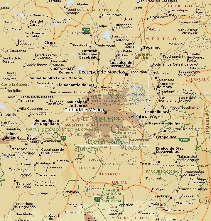
Mexico City - geography.
Publié le 27/05/2013

Extrait du document


«
Chapultepec Park also contains several museums.
The most important is the National Museum of Anthropology.
Other museums include Mexico's Museum of Modern Art andthe Museum of Natural History.
(These museums are described below in the section Education and Culture .)
Mexico City's major north-south artery is the Avenida Insurgentes, which stretches 30 km (21 mi).
It crosses the Paseo de la Reforma just north of the tourist area knownas the Zona Rosa (Spanish for “Pink Zone”).
Within this neighborhood are many of the principal hotels, restaurants, and fashionable stores catering to the tourist trade.
Southward along the Avenida Insurgentes, various stages of the city's growth can be seen.
In Colonia Juárez, just south of the Paseo de la Reforma, are elegant 19th-century mansions from the era of Mexican dictator Porfirio Díaz.
Less distinguished housing of pre-1940 vintage is located farther south.
Finally, as the Avenida Insurgentesapproaches the city’s boundaries, more affluent neighborhoods appear, with modern buildings, restaurants, and boutiques.
At the southern edge of the city, the National Autonomous University of Mexico straddles the Avenida Insurgentes.
On the western part of the campus is the 100,000-seatMexico 68 Olympic Stadium, site of the 1968 Olympic Games.
Just east of the Avenida Insurgentes is the university's main library.
The building and its famous tile mosaicexterior were designed by Juan O’Gorman.
Three-dimensional murals by Diego Rivera adorn the rectory on the main campus slightly farther to the east.
Outside the city, in the state of Mexico, lie major archaeological sites, including two important pyramids located at Teotihuacán, the capital of an ancient pre-Azteccivilization.
The two pyramids face each other on a north-south axis and are known as the Pyramid of the Sun and the Pyramid of the Moon.
Massive in size and height, theyprovide an extraordinary view of the surrounding region.
Mexico's leading religious shrine is located just north of Mexico City in the community of Gustavo A.
Madero (formerly Guadalupe Hidalgo).
In this community is a basilicathat marks the site of the appearance of the Virgin Mary to an indigenous peasant in 1531.
The Virgin of Guadalupe, as the apparition came to be called, became a symbolfor Mexican forces fighting to gain independence from Spain in the early 1800s.
As the patron saint of Mexico, the Virgin of Guadalupe is revered by millions of Mexicans.The shrine attracts more religious pilgrims than any other site in the country.
III POPULATION
The population of Mexico City proper was 14,007,495 in 2005.
The population of the metropolitan area reached 18.7 million in 2003.
The city's population growth wasphenomenal during most of the 20th century, spurred by migration from the provinces and a high birth rate.
From 1950 through 1970, the city’s population grew 4.2percent a year, from 3,050,000 in 1950 to 6,874,000 in 1970.
By 1980 the national census reported 8,831,000 people residing in Mexico City.
But from 1970 to 1990 theannual growth rate decreased to only 0.9 percent.
In part, the growth rate slowed after the mid-1970s because the government introduced a population control policy.
As late as 1970, the government denied that apopulation problem existed.
However, during the administration of Mexican president Luis Echeverría Álvarez (1970-1976) the government began a concerted effort toreduce birth rates, providing information on family planning through the national system of social security hospitals.
In the capital, the government began an advertisingcampaign suggesting smaller families as an ideal.
The government also began to encourage the creation of jobs in other regions of Mexico, which led to a sharp decrease in migration into Mexico City.
From 1985 to 1990,the Federal District lost over a million people, more than any Mexican state.
Nonetheless, in 1990 about 22 percent of the city's population had been born outside themetropolitan region.
During the 1980s and 1990s, the average age of the population in the metropolitan area increased as younger residents left Mexico City to pursueeconomic opportunities elsewhere.
The median age in the Federal District was 23 in 1990, higher than any of the states.
In 1995 the overall population density was about 6,600 persons per sq km (17,200 per sq mi).
In the past, the city center was by far the most densely settled part of thecity.
However, since the 1940s the outlying areas have absorbed most of the population increase.
Not surprisingly, the Federal District is more urban than any of theMexican states, with 99.7 percent of the population living in communities with more than 2,500 inhabitants.
Most of the people who live in Mexico City are mestizos —people of both Spanish and indigenous descent.
Nevertheless, variations exist within the mestizo population based on the ratio of Spanish to indigenous ancestry.
Most of the people in the city speak Spanish.
Mexico City has relatively few individuals who still speak Native Americanlanguages, unlike other regions of the country.
In 1990 only 1.5 percent of Federal District residents spoke Native American languages, compared to 7.5 percent nationally.
The major condition dividing the city's population is wealth.
The capital is a city of sharp social contrasts.
Wealthy residential sections are characterized by housing andsuburban retail centers that rival the most luxurious in the world.
A person can travel for miles in the affluent western and southern parts of the city without awareness ofbeing in an underdeveloped nation.
These neighborhoods are often in sharp contrast to the poorer sections, where housing is substandard, access to utilities and services islimited, and the standard of living is well below the poverty level.
These less affluent neighborhoods are found in the center of the city and to the north and east.
Ninety-two percent of the population professes membership in the Roman Catholic Church.
Only 3.2 percent are Protestant, and less than 0.3 percent are Jewish.
TheRoman Catholic Church plays an influential social and cultural role in the city.
More residents are members of church-affiliated organizations than of any other type.
Led byone of Mexico's cardinals, the diocese of Mexico City is the most important in the country.
It frequently publishes statements criticizing political and societal problems andemphasizing the need to reduce economic poverty.
IV EDUCATION AND CULTURE
Mexico City dominates the country's cultural life with a disproportionate number of universities, museums, and cultural institutions.
One-third of Mexico's institutions ofhigher learning are located in the capital, including its largest and most prestigious universities.
Most people who are educated in the capital remain there becauseuniversities provide the primary source of employment for cultural leaders in Mexico.
The dominant educational institution is the National Autonomous University of Mexico, which moved to its present site, known as University City, in 1952.
Its rapid rise inenrollment, from 40,000 in 1960 to 135,000 in the mid-1990s, reflects both the increase in the city's population and the rising aspirations of Mexicans.
To accommodate thesoaring student enrollments of the 1970s, the government created the Metropolitan Autonomous University, the largest university system in the country.
It provides a seriesof large campuses in various areas of the city, including working-class neighborhoods.
These campuses have increased access to higher education among lower-incomesocial groups.
Also of note is the National Polytechnic University.
Another institution, the Colegio de México, patterned after the United States university system, is widely known for itsgraduate program and its research in the social sciences.
Mexico City is also home to the National Center of the Arts, opened in 1994.
This architecturally impressivecomplex houses facilities for students of the fine arts, music, film, and drama and contains a library and concert hall.
In Mexico, many university campuses are highly political, and student groups often engage in ideological battles or become actively involved in national political issues.Universities are often the sites of strikes by university employees.
Several prestigious private colleges, including the Jesuit Ibero-American University and the AnáhuacUniversity, are havens from the social turmoil that frequently grips the large public institutions.
While nearly all of the children in Mexico City between the ages of 7 and 13 attend elementary school, one-third never progressed beyond the 6th grade.
There is a chronicshortage of school space, which is more acute at the secondary level.
School space is in short supply partly because so many people have moved to Mexico City from ruralareas..
»
↓↓↓ APERÇU DU DOCUMENT ↓↓↓
Liens utiles
- Mexico City - geography.
- Latin American Painting I INTRODUCTION Diego Rivera Museum Gallery The studio of Mexican painter Diego Rivera is now maintained as an art museum in Mexico City.
- Buenos Aires (city) - geography.
- Dublin (city, Ireland) - geography.
- Moscow (city, Russia) - geography.


